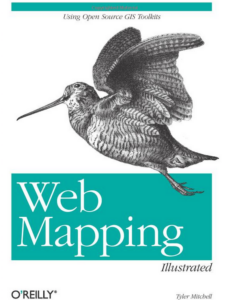
Web Mapping Illustrated – 10 year celebration giveaway [ENDED!]

web-mapping-tyler-mitchell-large
My O’Reilly, 2005 book

Update: All copies are gone!  If you want Geospatial Desktop or Geospatial Power Tools – go to LocatePress.com – quantity discounts available.  For Web Mapping Illustrated go to Amazon.


I’m giving away a couple copies of my circa 2005 classic book.  Details below…  When O’Reilly published Web Mapping Illustrated – Using Open Source GIS Toolkits – nothing like it existed on the market.  It was a gamble but worked out well in the end.

Primarily focused on MapServer, GDAL/OGR and PostGIS, it is a how-to guide for those building web apps that included maps.  That’s right, you couldn’t just use somebody else’s maps all the time – us geographers needed jobs, after all.

To help give you the context of the times, a couple months before the final print date, Google Maps, was released.  I blithely added a reference to their site just in case it became popular.

The book is still selling today and though I haven’t reviewed it in a while, I do believe many of the concepts are still as valid as when it was written.  In fact, it’s even easier to install and configure the apps now due to packaging and distribution options that didn’t exist back then.  Note this was also a year before OSGeo.org’s collaborative efforts started to help popularise the tools further.

In celebration of 10 years of sales I have a couple autographed copies as giveaways to the first two people who don’t mind paying only for the shipping (about USD$8) and who drop me a note expressing their interest.

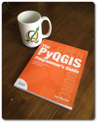
Additionally, I have some of Gary Sherman’s excellent Geospatial Desktop books as giveaways as well.  Same deal, pay actual shipping cost only from my remote hut in northern Canada.  Just let me know you’d like one of them and I’ll email you the PayPal details.  Sorry, not autographed by Gary, though I was editor and publisher, so could scribble on it for you if desired.

Geospatial Power Tools Reviews [Book]

Thinking of buying my latest book?  We’ve finally got a few reviews on Amazon that might help you decide.  See my other post for more about the book.  Buy the PDF on Locate Press.com.

Reader Reviews

Geospatial Power Tools book cover
From Amazon.com

5.0 out of 5 stars This book makes a great reference manual for using GDAL/OGR suite of command line …,
January 24, 2015 By Leo Hsu
“The GDAL Toolkit is chuckful of ETL commandline tools for working with 100s of spatial (and not so spatial data sources). Sadly the GDAL website only provides the basic API command switches with very few examples to get a user going with. I was really excited when this book was announced and purchased as soon as it came out. This book makes a great reference manual for using GDAL/OGR suite of command line utilities.
Several chapters are devoted to each commandline tool, explaining what its for, the switches it has, and several examples of how to use each one. You’ll learn how to work with both vector/(basic data no vector) data sources and how to convert from one vector format to another. You’ll also learn how to work with raster data and how to transform from one raster data source to another as well as various operations you can perform on these.”


Continue reading Geospatial Power Tools Reviews [Book]

PyQGIS Programmer’s Guide

I must confess, in all the years I’ve used QGIS I never did much of anything with the Python-QGIS API.  But now I can learn it

easily, and you can too, with the latest book from Locate Press:

PyQGIS Programmer’s Guide – Extending QGIS 2.x with Python

Written by Gary Sherman, the father of QGIS, you know it won’t be fluff!

Contents:

  1. Introduction
  2. Python Basics
  3. Setting Up Your Development Tools
  4. The QGIS/Python Ecosystem
  5. Navigating the QGIS API
  6. Using the Console
  7. Running Scripts
  8. Tips and Techniques
  9. Extending the API
  10. Writing Plugins
  11. Creating a Development Workflow
  12. Writing a Standalone Application
  13. Answers to Exercises
  14. Appendix A: Installing Software
  15. Appendix B: Code Listings
  16. Appendix C: Porting Scripts to 2.0


GDAL/OGR Book Released!

I’m happy to announced that Locate Press has just released a “first look” preview edition of my latest book…

Geospatial Power Tools – Open Source GDAL / OGR Command Line Utilities

Geospatial Power Tools - coverIt’s a 310 page collection of all the GDAL/OGR command utility documentation, written by the GDAL Developers.  Included are also about 100 pages of new content that shows more examples of how to use the various commands to do specific tasks.  This will help those who may not know what command to use, but who know what task they want to do – i.e. convert an image, mosaic images, query a WFS, etc.

From discussions I had over the past few years, it seemed many people needed this book or knew a colleague who could use it.  I know when I worked in forestry GIS and used these tools it was exciting, but my colleagues didn’t know about them and there wasn’t much available to help fill that gap.  I hope this book effort does help.

This is a PDF version so far, but expect a Kindle and paperback version around the end of the year!

20% off sale this weekend
coupon code “firstlook”!
 

GeoServer Beginner’s Guide

This past year I started using GeoServer more than I did before.  Actian is using it to demonstrate the capabilities of the Ingres 10S database sitting behind it.  So I was glad to see that there was a new book out on the topic, by Stefano Iacovella and Brian Youngblood.

It was very readable and went faster than I thought it would (maybe it would have been longer if I didn’t skip a few exercises 😉 ).  The book opens with the standard GIS Fundamentals but by the end of it you can be hacking XML and hitting the REST interface.

A few highlights to consider… Those who struggle with getting started with Tomcat on Linux will appreciate the chapter on installation.  Likewise there is a chapter pointing out how to better secure everything before going into production.

The book is packed full of screenshots and graphics, making it very easy to follow along.  The authors also did a great job making it readable and accessible.  I would recommend it for anyone who is a first time GeoServer user.  Check it out here.


%d bloggers like this: